Gpx
Advertisement
GPX and TCX file welder v.0.0.1
Substitutes the missing GPS information in Garmin TCX files when devices lacking a GPS receiver are used to collect training data (Garmin FR 60, heartrate and pedometer only). GpxTcxWelder integrates GPS info from a GPX v1.1 files into TCX files.
Advertisement
GPX Extractor v.0.2.10
Analyze GPX trackfiles fast and easy. GPX Extractor can analyze GPX trackfiles from Garmin GPS devices.GPX Extractor Features: 1. calculates track parameters 2. export track summary to xml fileRequirements: *
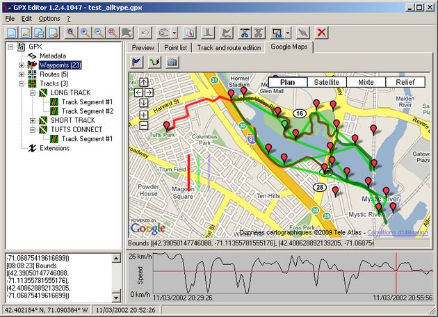
GeePeeEx Editor v.1 11
GeePeeEx Editor is specifically designed to produce and edit GPX files destined for Garmin's® Automotive Satnav (GPSr) systems. These files can be used as input to Garmin's® POI Loader to produce enhanced Custom POI's (Points of Interest).
IMGfromGPX v.1.0
Creating a map based on GPX files for your GPS and for MapSource/BaseCamp on your computer is possible with several existing programs, but it's certainly not easy to accomplish. With IMGfromGPX it's a matter of a few mouse clicks!
CacheMaps v.4. 1. 2008
CacheMaps retreives a variety of maps for your caches from the Internet. CacheMaps uses the Geocaching loc- or gpx-files as input. Directely from the Geocaching site or as exported from GSAK.CacheMaps v4 has been designed to be used next to GSAK.
JOSM v.4.399
Currently it supports loading stand alone GPX tracks and GPX track data from the OSM database as well as loading and editing existing nodes, ways, metadata tags and relations from the OSM database.
GeoGet v.2.6.2.663
GeoGet is a data manager. However, it is distributed without any data. The data content must be imported by you. You can import your PocketQuery GPX files, or you can save any Geocaching.
GPXtoPOI v.1.1.0.8
This program converts from GPX format to CSV format or vice versa. You can create waypoints in MapSource and then convert them to POI (CSV) files for download or sharing with others.
Grazer v.2 1
Grazer synchronizes GPX track files with images. It tells you where you took the image by analyzing when you took it. Grazer takes a GPX file and reads all elements of wptType, rteType and trkType from a specified file.
GPS2WorldWind v.1.0
With GPS2WorldWind you can: Create and display tracks, routes and waypoints Transfer waypoints, routes and tracks from/to your GPS device (see below 'Supported devices') Import Tracks, Waypoints and Routes from GPX, PCX5, OziExplorer or Google Map